Polygons, polylines and ground overlays are useful tools to make your maps work for your users. Today we are rolling out even more custom styling and data object association features in the Google Maps Android API to further help you customize your maps.
Style your shapes: polygons and polylines
We brought custom map styling to mobile platforms last year to help you match your map styles to your brands, apps, and more. We've seen hot pink, cool silver (shown in screenshots below), and everything in between, helping users feel at home and see what's relevant in your maps. Now we're expanding styling options for polygons and polylines, allowing you to use new stroke patterns for outlines, different caps and joints, and more, on Android devices.

Your shape, your style. Now on Android
Now you have plenty of options to customize your shapes. You can change the stroke patterns in polylines and polygon outlines from solid lines to custom dashes, dots, or gaps. In polylines and polygons, you can use a bevel or round joint type rather than fixed miter joints. You can also change the cap at each end of a polyline to a square or round cap, or even specify a custom bitmap for the cap. Have a favorite fancy arrowhead you've always wanted to put in? Do it–let your imagination run wild!
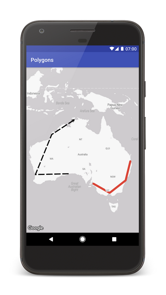
Get your styles in line. Now on Android.
Learn how to set and customize these new styles in our new polyline and polygon tutorial or dive straight into the documentation to get started—check out the stroke patterns, for example. Note that these new styling features are available in the full Google Maps Android API only, not in lite mode.
Store custom data with polygons, polylines, and ground overlays
Until today, you could only store data objects with markers. We're extending this functionality to polygons, polylines, circles, and ground overlays. This means you can extend your geometry objects to have any kind of data or properties you want. You no longer need to manage your data associations to your mapping visualizations–nobody enjoys writing that code anyway. For example, if you supply a set of ground overlays showing home floor plans you could store a database reference with each one. The database can contain anything! It could hold real estate listings, and you could open one of those listing URLs on click.
For further information, review our release notes.
Thank you for using the Google Maps Android API! Be sure to share your feedback or any issues in the issue tracker.