Editor’s note: Today’s post is from Christophe Hardy, Toyota Motor Europe’s Manager of Social Business. He’ll explain how Toyota used Google Maps APIs to build an Android app to keep teen drivers safe. ...


Editor’s note: Today’s post is from Christophe Hardy, Toyota Motor Europe’s Manager of Social Business. He’ll explain how Toyota used Google Maps APIs to build an Android app to keep teen drivers safe.

It’s a milestone that teenagers celebrate and parents fear: getting that first driver’s license. For teens, a license means freedom and a gateway to adulthood. For parents, it means worrying about their kid’s safety, with no way to make sure they’re doing the right thing behind the wheel.

We know that the risk of motor vehicle crashes is higher among 16-19-year-olds than any other age group, and that speeding and using smartphones are two of the main main causes. So as part of Toyota's efforts to eliminate accidents and fatalities, we worked with Molamil and MapsPeople to build Safe and Sound, an Android app for European teen drivers. It takes a lighthearted but effective approach to help young drivers stay focused on speed limits and the rules of the road, not on their cellphones. And it can be used by anyone, not just Toyota owners.

One way Safe and Sound combats speeding and distracted driving is by using music. Before parents turn over their car keys, parents and teens download and run the app to set it up. The app syncs with Spotify, and uses the Google Maps Roads API to monitor a teen’s driving behavior. If Safe and Sound determines the teen is speeding, it’ll override the teen’s music with a Spotify playlist specifically chosen by the parent—and the teen can’t turn it off. As any parent knows, parents and kids don’t always agree on music. And there’s nothing less cool to a teen than being forced to listen to folk ballads or ‘70s soft rock. (The embarrassment doubles if their friends are in the car.) The parents’ playlist turns off and switches back to the teen’s only when the teen drives at the speed limit.

The app also helps prevent distracted driving. When it detects the car is moving above nine miles an hour, it switches on a “do not disturb” mode that blocks social media notifications, incoming and outgoing texts, and phone calls. If the teen touches the phone, the app will detect that too, and play the parents' Spotify playlist until the teen removes his or her hand. At the end of the drive, Safe and Sound alerts parents to how many times their teen exceeded the speed limit or touched the phone. Parents can also tap a link in the app that displays the route the teen drove in Google Maps.

Google Maps provided us the ideal platform for building Safe and Sound. It has accurate, up-to-date and comprehensive map data, including road speed limits. The documentation is great, which made using the Google Maps Roads API simple. It also scales to handle millions of users, an important consideration as we roll out the app to more of Europe.

Safe and Sound is currently available in English throughout the continent, with a Spanish version launching soon in Spain, and a Dutch and French version coming to Belgium. And we’re looking to localize Safe and Sound into even more languages.

We hope Safe and Sound helps keep more teens safe, and brings more parents peace of mind. Plus, there’s never been a better use for that playlist of yacht rock classics.

Back in 2012, we launched the Place Add / Delete feature in the Google Places API to enable applications to instantly update the information in Google Maps’ database for their own users, as well as submit new places to add to Google Maps. We also introduced ...
Back in 2012, we launched the Place Add / Delete feature in the Google Places API to enable applications to instantly update the information in Google Maps’ database for their own users, as well as submit new places to add to Google Maps. We also introduced Radar Search to help users identify specific areas of interest within a geographic area.

Unfortunately, since we introduced these features, they have not been widely adopted, and we’ve recently launched easier ways for users to add missing places. At the same time, these features have proven incompatible with future improvements we plan to introduce into the Places API.

Therefore, we’ve decided to remove the Place Add / Delete and Radar Search features in the Google Places API Web Service and JavaScript Library. Place Add is also being deprecated in the Google Places API for Android and iOS. These features will remain available until June 30, 2018. After that date, requests to the Places API attempting to use these features will receive an error response.

Next steps

We recommend removing these features from all your applications, before they are turned down at the end of June 2018.

Nearby Search can work as an alternative for Radar Search, when used with rankby=distance and without keyword or name. Please check the Developer's Guide for more details, in the Web Service or Places library in the Google Maps JavaScript API.

The Client Libraries for Google Maps Web Services for Python, Node.js, Java and Go are also being updated to reflect the deprecated status of this functionality.

We apologize for any inconvenience this may cause, but we hope that the alternative options we provide will still help meet your needs. Please submit any questions or feedback to our issue tracker.

author image
Posted by Fontaine Foxworth, Product Manager, Google Maps APIs

Last week at Google I/O we announced Google Maps URLs, a new way for developers to link directly to Google Maps from any app. Over one billion people use the Google Maps apps and sites every month to get information about the world, and now we're making it easier to leverage the power of our maps from any app or site.

Why URLs?

Maps can be important to help your users get things done, but we know sometimes maps don't need to be a core part of your app or site. Sometimes you just need the ability to complete your users’ journey—including pointing them to a specific location. Maybe they're ready to buy from you and need to find your nearest store, or they want to set up a meeting place with other users. All of these can be done easily in Google Maps already.

What you can do is use Google Maps URLs to link into Google Maps and trigger the functionality you or your users need automatically. Google Maps URLs are not new. You've probably noticed that copying our URLs out of a browser works—on some platforms. While we have Android Intents and an iOS URL Scheme, they only work on their native platforms. Not only is that more work for developers, it means any multi-user functionality is limited to users on that same platform.

Cross platform

So to start, we needed a universal URL scheme we could support cross-platform—Android, iOS, and web. A messaging app user should be able to share a location to meet up with their friend without worrying about whether the message recipient is on Android or iOS. And for something as easy as that, developers shouldn't have to reimplement the same feature with two different libraries either.

So when a Google Maps URL is opened, it will be handled by the Google Maps app installed on the user's device, whatever device that is. If Google Maps for Android or iOS is available, that's where the user will be taken. Otherwise, Google Maps will open in a browser.

Easy to use

Getting started is simple—just replace some values in the URL based on what you're trying to accomplish. That means we made it easy to construct URLs programmatically. Here are a few examples to get you started:

Say someone has finished booking a place to stay and need figure out how to get there or see what restaurants are nearby:
https://www.google.com/maps/search/?api=1&query=sushi+near+94043
The query parameter does what it says: plugs a query in. Here we've specified a place, but if you do the same link with no location it will search near the user clicking it. Try it out: click here for sushi near you.

This is similar to our query above, but this time we got back a single result, so it gets additional details shown on the page:
google.com/maps/search/?api=1&query=shoreline+amphitheatre
The api parameter (mandatory) specifies the version of Maps URLs that you're using. We're launching version 1.


Or if a user has set up their fitness app and want to try out a new route on their bike:
www.google.com/maps/dir/?api=1&destination=stevens+creek+trail&travelmode=bicycling&dir_action=navigate
We can specify the travelmode to bicycling, destination to a nearby bike trail, and we're done!

And we can also open StreetView directly with a focus of our choice to give a real sense of what a place is like:
www.google.com/maps/@?api=1&map_action=pano&viewpoint=36.0665,-112.0906&heading=85&pitch=10&fov=75
The viewpoint is a LatLng coordinate we want to get imagery for, and heading, pitch, and fov allows you to specify exactly where to look.

Need more functionality?

Google Maps URLs are great to help your users accomplish some tasks in Google Maps. However, when you need more flexibility, customization, or control, we recommend integrating Google Maps into your app or site instead. This is where our more powerful Google Maps APIs come into play. With our feature-rich range of APIs, you can access full functionality and can control your camera, draw shapes on the map, or style your maps to match your apps, brand, or just for better UI. And if you want to go beyond the map we have metadata on Places, images, and much more.

Learn more

When you're happy to delegate the heavy lifting and make use of the Google Maps app for your needs, Maps URLs are for you. Check out our new documentation.

Thank you for using Google Maps URLs and the Google Maps APIs! Be sure to share your feedback or any issues in the issue tracker.

author image
Posted by Joel Kalmanowicz, Product Manager, Google Maps APIs


Particle and Google Maps make it easy for IoT devices to identify their location without the use of a GPS. With a single line of code, a device or sensor dispersed across a network (an IoT edge device) can access Google’s geospatial database of Wi-Fi and cellular networks using the ...


Particle and Google Maps make it easy for IoT devices to identify their location without the use of a GPS. With a single line of code, a device or sensor dispersed across a network (an IoT edge device) can access Google’s geospatial database of Wi-Fi and cellular networks using the Google Maps Geolocation API.

This means you no longer need to invest in expensive and power hungry GPS modules to know the location of their IoT devices and sensors. Alternatively, you can also use Google Maps APIs in conjunction with existing GPS systems to increase accuracy and provide location data even when GPS fails, as it often does indoors.

Particle and Google now provide the whole chain—location aware devices that send context rich data to Google Cloud Platform. When IoT sensors know their location, the information they collect and send back becomes more contextualized, allowing you to make more informed, high-order decisions. By feeding context-rich data back into Google Cloud Platform, you have access to robust set of cloud products and services.

Although asset tracking is traditionally built on a foundation that includes GPS, satellite based GPS often fails in dense urban environments and indoors. In these scenarios, GPS signals are blocked by tall buildings or roofs. The Geolocation API is based on cell tower and Wi-Fi signals that continue to operate where GPS fails. This capability allows you to track your assets anywhere, both indoor and out.

In an IoT driven world, you can track more than just location. Additional signals can be critical to your objectives. For example, in the cold supply chain, temperature as well as location are key pieces of data to track in the factory, on the loading dock and in transit. This enables a holistic view of the supply chain and its ability to deliver a high quality product.
With a Wi-Fi enabled product built on the Particle platform, you can use the Google Maps Geolocation API to offer location aware auto configuration. This creates a seamless setup experience, enhanced operation and valuable analytics. Using geolocation your Particle devices can auto configure timezone, tune to available broadcast bands and connect to regional service providers.

For example, location aware window blinds can reference the number of available hours of sunlight and then make informed decision on how to passively heat a room. A smart coffee machine can report back its location allowing your marketing teams to better understand its market penetration and target demographic.

Visit the documentation for full directions to enable geolocation on your Particle devices. There are four basic steps to complete:

  1. Get a Google Maps API key enabled for Geolocation.
  2. Flash the Google Maps Firmware on your Particle Devices.
  3. Enable the Google Maps Integration in the Particle Console.
  4. Test it Out!

Google and Particle will be demoing the integration at IoT World beginning May 16. Stop by booth #310 near the main hall entrance to see the demo in person or for more information, review our developer documentation and get started today.

author image
About Ken: Ken is a Lead on the Industry Solutions team. He works with customers to bring innovative solutions to market.

Every day, millions of people search on Google for places to eat and drink and many click to see the menu before making a decision. In fact, the Google search interest in "menu" related queries has seen a 30% increase in the last 2 years*. For businesses, this means they need to provide useful and relevant information to their customers in these moments that matter.

Last December, we enabled Menu URL editing in the Google My Business API allowing businesses to control and manage their menu link on Google Maps and Search. Starting today, businesses that use the Google My Business API can publish their entire menu to Google —itemized with descriptions, photos and prices--making it frictionless for their customers to view their menus on Google.

Arby’s, the quick-serve fast-food sandwich restaurant chain, was one of the first to take advantage of this feature and publish their full menu to Google. Now customers who search on Google for Arby’s can find accurate and up-to-date menu information provided by Arby’s as well as photos of those menu items.

"We update our menu every month with new and limited time offers. With the new Google My Business Menu feature we now have control over our menu data. We are able to provide our menu updates directly to Google via the Yext platform, and our updated menu populates on Google almost instantly. We no longer have to worry about old, unavailable menu items from third party sites showing up." said Sonja Uppal, Arby’s Digital Marketing Supervisor.

Developers can now use the Google My Business API to publish menu data to each of their business locations and see it update on Google in minutes. They’ll be able to publish multiple menus (e.g. breakfast, lunch, dinner) with sections (e.g. salads, entrees, dessert, drinks) that include individual menu items, each with a rich description, photo and price. It's easy to get started with our new developer documentation.

Here's a simple JSON request that shows how to publish a simple breakfast menu to a location:

REQUEST:
PATCH
https://mybusiness.googleapis.com/v3/123456/locations/
654321?languageCode=en-US&fieldMask=priceLists

 {
  "priceLists": [
    {
      "priceListId": "Breakfast",
      "labels": [
        {
          "displayName": "Breakfast",
          "description": "Tasty Google Breakfast",
          "languageCode": "en-US"
        }
      ],
      "sourceUrl": "http://www.google.com/todays_menu",
      "sections": [
        {
          "sectionId": "entree_menu",
          "labels": [
            {
              "displayName": "Entrées",
              "description": "Breakfast Entrées",
              "languageCode": "en-US"
            }
          ],
          "items": [
            {
              "itemId": "scramble",
              "labels": [
                {
                  "displayName": "Big Scramble",
                  "description": "A delicious scramble filled with Potatoes, Eggs, 
                  Bell Peppers, and Sausage",
                  "languageCode": "en-US"
                }
              ],
              "price": {
                "currencyCode": "USD",
                "units": "12",
                "nanos": "200000000"
              },
              "photoUrls": [
                "http://www.google.com/images/breakfast_scramble1.jpg",
                "http://www.google.com/images/breakfast_scramble2.jpg"
              ]
            },
            {
              "itemId": "steak_omelette",
              "labels": [
                {
                  "displayName": "Steak Omelette",
                  "description": "Three egg omelette with grilled prime rib, 
                   fire-roasted bell peppers and onions, saut\u00e9ed mushrooms
                   and melted Swiss cheese",
                  "languageCode": "en-US"
                }
              ],
              "price": {
                "currencyCode": "USD",
                "units": "15",
                "nanos": "750000000"
              }
            }
          ]
        }
      ]
    }
  ]
}

RESPONSE:

Response will contain an instance of the updated Location Object.

To learn more about the Google My Business API and to apply for access, visit our developer page. Questions or feedback? Contact the API team on the Google My Business API Forum.


author image
Posted by Aditya Tendulkar, Product Manager, Google My Business

*Google Trends


Starting today, we’re working on facilitating better collaboration between you and the Google Maps APIs product teams, by upgrading to Issue Tracker, a tool we also use internally at Google. We have migrated all issues from the old ...


Starting today, we’re working on facilitating better collaboration between you and the Google Maps APIs product teams, by upgrading to Issue Tracker, a tool we also use internally at Google. We have migrated all issues from the old code.google.com tracker to the new Issue Tracker hosted at issuetracker.google.com.
issuetracker.png
New Google Issue Tracker
code_small.png
Old Google Code issue tracker

Getting started with Google Issue Tracker should be easy. Check out our documentation for more information about how to create, edit, search, and group issues. By default, Google Issue Tracker only displays issues assigned to you, but you can easily change that to show a hotlist of your choice, a bookmark group or saved searches. You can also adjust notification settings by clicking the gear icon in the top right corner and selecting settings. For more information, check out the discussion of notification levels in the developer documentation.
issuetracker_maps_bookmark_group.png
The Google Maps APIs bookmark group

Searching for product-specific issues

Opening any code.google.com issue link will automatically redirect you to the new system. You’ll be able to find all of the issues from code.google.com in the Issue Tracker, including any issue you have reported, commented on, or starred. If you feel like anything is missing, let us know (how meta!) -- we have backups available!

Google Issue Tracker organizes issues into a component hierarchy. Starting at the Google Maps APIs bookmark group, you can drill down to a particular product's issues. And because each product (and some product features) have their own component, you can easily search for them. For example, you can view all Google Maps JS API v3 or Places API reports, which correspond to the old tracker’s full list for Maps API JS v3 and Places API. You can find the full list of Google Maps APIs components in the support section of our developer documentation. To search within those issues, leave the component ID in the search bar; removing it will search public issues from all Google products.

For detailed instructions on how to create issues check out this guide, Still have questions? Take a peek at our FAQ. If you can’t find the answer please let us know by commenting on this post.

The Google Maps APIs team wants your feedback!

Your feedback is important to us and makes a big difference! Make sure to take advantage of the starring feature for any issues you’re interested in to help us prioritize. As an example, after reviewing your feedback, we recently implemented Styled Maps for Google Maps Android API (received 365 stars) and Google Maps SDK for iOS (received 245 stars).

Please continue helping us improve our products by reporting issues and feature requests!

Next 2017 is just a few days away and we’re looking forward to three days of insightful conversations, amazing technology and, of course, beautiful San Francisco. This year, Google Maps APIs business leaders, engineers, product managers, technical writers, and developer advocates are traveling from Sydney, New York and Mountain View to spend time with our customers and partners. We’re looking forward to sharing how our APIs help build the best location-based experiences for your customers.

Here are our sessions at Google Cloud Next ‘17:

Day 1 (March 8)

Make better business decisions with Google Maps, Dave McClusky (Global Head of Customer Engineering), Adam Evans (Head of Field Sales, US/Canada).
11:20am room 2010

Location as a force multiplier: redefining what's possible for enterprises, Gayathri Rajan (VP Product Management).
1:20pm room 3018

Development best practices for Google Maps mobile and web service APIs, Dave McClusky (Global Head of Customer Engineering), Emily Keller (Technical Program Manager).
2:40pm room 3014

Flexible development with the Google Maps APIs, Ankur Kotwal (Developer Advocate).
4:00pm room 3018

    Day 2 (March 9)

    The power of Geolocation, Laurence Moroney (Developer Advocate).
    11:30am room 3018

    Location-powered, on-demand economy: providing value with Google Maps APIs, Vishal Goenka (Group Product Manager).
    1:30pm room 3018

    Real world gaming: using location data to build immersive mobile experiences, Clementine Jacoby (Associate Product Manager).
    2:40pm room 3018

    The primary key to location intelligence, Ankur Kotwal (Developer Advocate), Laurence Moroney (Developer Advocate).
    4:00pm room 3018

      We hope you’re able to attend these sessions to learn directly from the Google Maps APIs team. In the Application Development Showcase, we will also have a number of innovative demos built on the Maps APIs. And, don’t forget to stop by the Meet the Experts zone on Level 1 of Moscone West to chat. If you’re not able to join us in person this year, you can always keep up with our activities via Twitter or Google+.

      author image
      Posted by Ankur Kotwal, Developer Advocate at Google

      Until recently, our docs have focused on describing features rather than telling a story. We chatted to some developers and came up with a new design for our tutorials. We’d love to know what you think of them.
      Until recently, our docs have focused on describing features rather than telling a story. We chatted to some developers and came up with a new design for our tutorials. We’d love to know what you think of them.

      Developers tell us they want quick, straightforward guides on how to integrate the Google Maps APIs into their app. The most common thing people want to do is to add a map with a marker. Just show me how to do that.


      Developers are also looking for complete, step-by-step tutorials for the most common use cases. Guides that go all the way from a to z, with no deviations.

      And they want code. Front and foremost. All the code.

      Here are some examples of the new-look tutorials:


      Each tutorial provides the entire development project, especially useful for the native mobile APIs. The doc page goes hand in hand with a new sample app on GitHub. For example, here’s the code for the current place tutorial on Android.

      Each page includes a visual illustration of what you’ll achieve by following the tutorial. A working demo is ideal (such as the visualizing data tutorial for the Google Maps JavaScript API), otherwise a screenshot (as we’ve done for the native mobile APIs).

      We want to make it easy for developers to find the guides. So, we’re adding tutorial showcases to the API overview pages. To date we’ve created the showcases for Android, iOS, and JavaScript. We’re also collecting together all the tutorials for the Maps JavaScript API in one place.


      We’ve made a good start, but there’s plenty of change still to come. What would you like to see more of? Are we on the right track? The tech writing team would love your ideas—please add comments to this post.

      author image
      Posted by Sarah Maddox, Technical Writer, Google Maps APIs


      Polygons, polylines and ground overlays are useful tools to make your maps work for your users. Today we are rolling out even more custom styling and data object association features in the Google Maps Android API to further help you customize your maps.
      Polygons, polylines and ground overlays are useful tools to make your maps work for your users. Today we are rolling out even more custom styling and data object association features in the Google Maps Android API to further help you customize your maps.


      Style your shapes: polygons and polylines

      We brought custom map styling to mobile platforms last year to help you match your map styles to your brands, apps, and more. We've seen hot pink, cool silver (shown in screenshots below), and everything in between, helping users feel at home and see what's relevant in your maps. Now we're expanding styling options for polygons and polylines, allowing you to use new stroke patterns for outlines, different caps and joints, and more, on Android devices.
      Polygons.png
      Your shape, your style. Now on Android

      Now you have plenty of options to customize your shapes. You can change the stroke patterns in polylines and polygon outlines from solid lines to custom dashes, dots, or gaps. In polylines and polygons, you can use a bevel or round joint type rather than fixed miter joints. You can also change the cap at each end of a polyline to a square or round cap, or even specify a custom bitmap for the cap. Have a favorite fancy arrowhead you've always wanted to put in? Do it–let your imagination run wild!
      Polylines.png
      Get your styles in line. Now on Android.

      Learn how to set and customize these new styles in our new polyline and polygon tutorial or dive straight into the documentation to get started—check out the stroke patterns, for example. Note that these new styling features are available in the full Google Maps Android API only, not in lite mode.

      Store custom data with polygons, polylines, and ground overlays

      Until today, you could only store data objects with markers. We're extending this functionality to polygons, polylines, circles, and ground overlays. This means you can extend your geometry objects to have any kind of data or properties you want. You no longer need to manage your data associations to your mapping visualizations–nobody enjoys writing that code anyway. For example, if you supply a set of ground overlays showing home floor plans you could store a database reference with each one. The database can contain anything! It could hold real estate listings, and you could open one of those listing URLs on click.

      For further information, review our release notes.

      Thank you for using the Google Maps Android API! Be sure to share your feedback or any issues in the issue tracker.

      author image
      Posted by Joel Kalmanowicz, Product Manager, Google Maps APIs


      We are excited to announce that we are open-sourcing Google Earth Enterprise (GEE), the enterprise product that allows developers to build and host their own private maps and 3D globes. With this release, GEE Fusion, GEE Server, and GEE Portable Server source code (all 470,000+ lines!) will be published on GitHub under the Apache2 license in March.
      Screen Shot 2017-01-26 at 2.51.24 PM.png

      Originally launched in 2006, Google Earth Enterprise provides customers the ability to build and host private, on-premise versions of Google Earth and Google Maps. In March 2015, we announced the deprecation of the product and the end of all sales. To provide ample time for customers to transition, we have provided a two year maintenance period ending on March 22, 2017. During this maintenance period, product updates have been regularly shipped and technical support has been available to licensed customers.

      Feedback is important to us and we’ve heard from our customers that GEE remains in-use in mission-critical applications. Many customers have not transitioned to other technologies. Open-sourcing GEE allows our customer community to continue to improve and evolve the project in perpetuity. Note that the implementations for Google Earth Enterprise Client, Google Maps JavaScript® API V3 and Google Earth API will not be open sourced. The Enterprise Client will continue to be made available and updated. However, since GEE Fusion and GEE Server are being open-sourced, the imagery and terrain quadtree implementations used in these products will allow third-party developers to build viewers that can consume GEE Server Databases.

      We’re thankful for the help of our GEE partners in preparing the codebase to be migrated to GitHub. It’s a lot of work and we cannot do it without them. It is our hope that their passion for GEE and GEE customers will serve to lead the project into its next chapter.

      Looking forward, GEE customers can use Google Cloud Platform (GCP) instead of legacy on-premises enterprise servers to run their GEE instances. For many customers, GCP provides a scalable and affordable infrastructure as a service where they can securely run GEE. Other GEE customers will be able to continue to operate the software in disconnected environments. However, we believe that the advantages of incorporating even some of the workloads on GCP will become apparent (such as processing large imagery or terrain assets on GCP that can be downloaded and brought to internal networks, or standing up user-facing Portable Globe Factories).

      Moreover, GCP is increasingly used as a source for geospatial data. Google’s Earth Engine has made available over a petabyte of raster datasets which are readily accessible and available to the public on Google Cloud Storage. Additionally, Google uses Cloud Storage to provide data to customers who purchase Google Imagery today. Having access to massive amounts of geospatial data, on the same platform as your flexible compute and storage, makes generating high quality Google Earth Enterprise Databases and Portables easier and faster than ever.

      We will be sharing a series of white papers and other technical resources to make it as frictionless as possible to get open source GEE up and running on Google Cloud Platform. We are excited about the possibilities that open-sourcing enables, and we trust this is good news for our community. We will be sharing more information when we launch the code in March on GitHub. For general product information, visit the Google Earth Enterprise Help Center. Review the essential and advanced training for how to use Google Earth Enterprise, or learn more about the benefits of Google Cloud Platform.


      Today we are introducing business location insights in the Google My Business API to make it easier for third-party application developers and large multi-location brands to programmatically access location insights such as total number of searches, views and actions that let business owners track and analyze where and how people are finding them on Google.


      Today we are introducing business location insights in the Google My Business API to make it easier for third-party application developers and large multi-location brands to programmatically access location insights such as total number of searches, views and actions that let business owners track and analyze where and how people are finding them on Google.

      Developers can now use the Google My Business API to request up to 18 months worth of data for each of their business locations and build applications that aggregate and visualize these insights in actionable ways. For example, a coffee shop with hundreds of locations can now easily compare and understand trends across their different locations such as number of user views, click requests for directions, phone calls, and more. They can use these insights to better allocate resources across locations and track how marketing activities affect their business.

      This new API functionality brings the features from our Google My Business dashboard into your own data analysis tools. Web interface users might generate a chart of the last 90 days of Google My Business information:
      Example data visible via the Google My Business web dashboard

      Now the underlying data is available via the API. It's easy to get started with our new developer documentation. Here's a simple HTML request that provides a breakdown of how many searches a business listing is getting on Google Search and Google Maps:

      REQUEST:
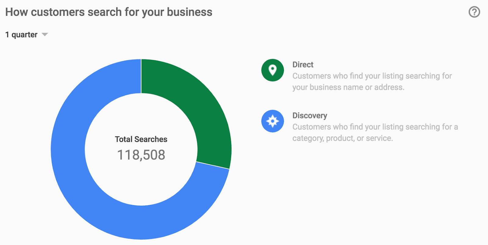
      POST https://mybusiness.googleapis.com/v3/123456/locations:reportInsights
      {
        "locationNames": [
          “accounts/110714876951578713336/locations/14372810722634034850”,
        ],
        “basicRequest” : {
                "metricRequests": [
                   {
                     "metric": QUERIES_DIRECT,
                   },
                   {
                     "metric": QUERIES_INDIRECT,
                   }
                ],
                "timeRange": {
                     "startTime": 2016-10-12T01:01:23.045123456Z,
                     "endTime": 2017-01-10T23:59:59.045123456Z,
                },
          },
      }

      RESPONSE:
      {
        "locationMetrics": [
          {
            "locationName": "accounts/110714876951578713336/locations/
                             14372810722634034850",
            "timeZone": "America/Los_Angeles",
            "metricValues": [
              {
                "metric": "QUERIES_DIRECT",
                "totalValue": {
                  "metricOption": "AGGREGATED_TOTAL",
                  "timeDimension": {
                    "timeRange": {
                      "startTime": "2016-10-12T04:00:00Z",
                      "endTime": "2017-01-10T04:00:00Z"
                    }
                  },
                  "value": "36738"
                }
              },
              {
                "metric": "QUERIES_INDIRECT",
                "totalValue": {
                  "metricOption": "AGGREGATED_TOTAL",
                  "timeDimension": {
                    "timeRange": {
                      "startTime": "2016-10-12T04:00:00Z",
                      "endTime": "2017-01-10T04:00:00Z"
                    }
                  },
                  "value": "81770"
                }
              }
            ]
          }
        ]
      }

      Here is an example that captures insights on the places from where customers request driving directions to a business:

      REQUEST:
      POST https://mybusiness.googleapis.com/v3/123456/locations:reportInsights
      {
           “locationNames": [
                   “accounts/110714876951578713336/locations/14372810722634034850”,
             ],
            "drivingDirectionsRequest”: {
                  "numDays": NINETY,
            },
      }

      RESPONSE (truncated to show first 3 results):
      {
        "locationDrivingDirectionMetrics": [
          {
            "locationName": "accounts/110714876951578713336/locations/
                             14372810722634034850",
            "topDirectionSources": [
              {
                "dayCount": 90,
                "regionCounts": [
                  {
                    "latlng": {
                      "latitude": 37.789,
                      "longitude": -121.392
                    },
                    "label": "94105",
                    "count": "2980",
                  },
                  {
                    "latlng": {
                      "latitude": 37.779,
                      "longitude": -122.421
                    },
                    "label": "94102",
                    "count": "887",
                  },
                  {
                    "latlng": {
                      "latitude": 37.773,
                      "longitude": -122.410
                    },
                    "label": "94103",
                    "count": "886",
                  }
                ]
              }
            ],
                "timeZone": "America/Los_Angeles"
          }
        ]
      }
      Example data visible via the Google My Business web dashboard

      With this new feature, Google My Business API users can optimize their listings to drive customer actions through understanding key insights about how customers are searching for their business on Google, and what actions they are taking once they find it. These insights are also available on Google My Business web and mobile, allowing users to keep track of key trends from anywhere.

      To learn more about the Google My Business API and to apply for access, visit our developer page. Questions or feedback? Contact the API team on the Google My Business API Forum.